It’s a two hour drive from home to Mardale. An early start for potential sunrise shoot, even in winter. Sunrise at Mardale was around 8am. There were two locations to try out on this trip, well, one was more of a hike with a camera, the other was the popular spot of the ruined shepherds huts on Mardale Common. A 5am wakeup, with an aim to be setting off by 5.30.
With the darkness releasing its long grip of a winters night, by the time I’m near Ingleton, I can make out the silhouettes of Ingleborough and can also see that the skies are fairly clear with a few large patches of clouds. Hope rises of a colourful predawn sky.
Passing by Tebay with reluctance (their sausage sandwiches are very nice) I leave the M6 and head through Shap and into Mardale. The skies are still clear, and I make my mind to call in at the shepherds huts first. This isn’t known as a good sunrise location, the sun doesn’t cast light onto the huts until a couple of hours after sunrise but I’m after the imposing peaks opposite with a lovely fresh layer of snow and colourful clouds above, hopefully reflected upon the surfaces of Lake Haweswater (ok, it’s a reservoir not a lake!)

Phone grab, from the fast walk up the hill to the first spot.
I get the last spot in the layby. Looks like I’ll have company up there. Following the path, referred to as the corpse road in a nod to its original propose, of carrying the dead from Mardale, over the fell into consecrated ground at Shap. Its quite a steep path and I arrive huffing and puffing twenty minutes later. Expecting to see other togs, I was surprised that there was no one else around. I wonder where the owners of the other four cars are. presumably wild camping.
There are a few ruined huts here, I count at least five. Three are still relatively intact, minus their roofs. When I arrived, I could see the mountains and the lovely fresh snow upon their peaks. In the twenty minutes it took to get the spot. In that time, a large bank of cloud had rolled in from the north. The huts are at a height of 400-430metres (1300-1400ft) This cloud has a base of around 600-700 meters, most of the surrounding peaks are above 700meters. Its 8am, the sun has risen, there hasn’t been the colourful spectacle I was longing for.
I decided to stick around, to see what would happen. There are certainly much worse places to spend a couple of hours. I enjoyed the peace and tranquillity. No cars, no people, only a few corvidae for company.

The very popular shot of the lower ruin overlooking Haweswater Reservoir
After a couple of hours hoping the cloud would move away and the sun would shine down upon the land. It was clear that this cloud was more of a weather front and was likely going to be here all day and probably longer! Packed up and wondered down to the car. Its two minutes from here to the main car park at Mardale.
From here, my intention is to head up High street mountain and along the ridge and back down at Nan Bield Pass. Even though the cloud hasn’t risen or broken, the optimist in me set off. Its about an hour to the top of Rough Cragg (longer if you’re a photographer!) And I’ll call it there. The fresh snow was rather slippy underfoot, I did have the mini spikes but the cover was thin and starting to melt, there wouldn’t be any bite. So I slip and slide my way up, stopping occasionally for a nice scene.

Looking back from Rough Cragg.
At the top of Rough Cragg, I stop to take a few pics, the sun does break through briefly, highlighting the lovely crags upon the mountain sides. From this vantage spot, I can spy a rather well trodden footpath down by Blea Water. It seems fruitless to head any higher, the images I had a mind to try and capture won’t be possible in thick cloud. So its time to make my way down to Blea Water and intercept that inviting path. It’s steep, across the grasses made slippy by the damp conditions and patches of snow. It seems to take an eternity to hit the path but I do and i’m soon heading towards to the car park.
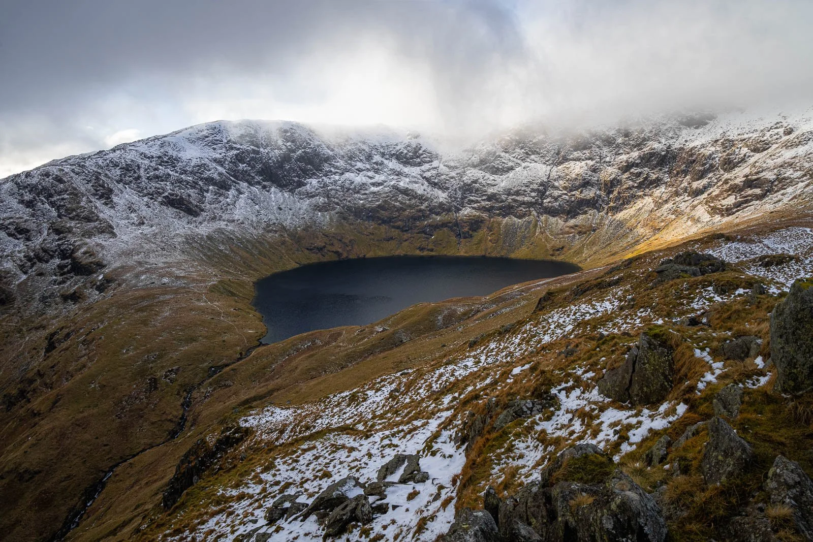
From Rough Cragg looking at Blea Water, one of the deepest mountain tarns in England at 62m
This path is very boggy. I’m very happy for my waterproof socks. My gaters have given up by this point and the elastic has snapped, so they now doing an excellent impression of Nora Battys tights. There are one or two compositions on this route which I spend a few mins on but by this time, I’m feeling the early start and the exertions of the day and the light is very flat. These shots are more record shots of potential future shots with nice light. There’s a lovely waterfall lower down, which I only briefly glance at. Energy has gone and there is a two hour drive ahead of me.

Looking down Mardale, with Blea Water beck flowing down towards Haweswater.
An enjoyable day, a mix of photographer frustrations but hikers pleasures.